
 |
| Juan Bautista de Anza National Historic Trail Guide |
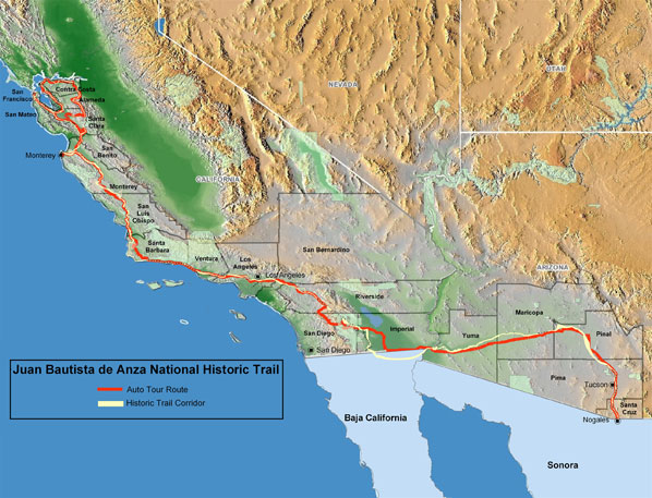 |
The overview map above and the (680 Kb) pdf
format map of the counties can help travelers tell which county they
are in on the trail.
Detailed maps are found in the individual county web pages that can be reached from the Select A County pulldown list above.
There is also a trail
brochure driving map in pdf format (770 Kb).
See the complete map
of the Anza Expedition, as informed by Father Pedro Font,
Chaplain and diarist of the expedition.
|
The Juan Bautista
de Anza National Historic Trail is a 1,210-mile historic route
from Nogales, Arizona to San Francisco, California. The trail commemorates
the story of the 1775-1776 Spanish Expedition whose members, consisting
of some 30 families, experienced this overland route on their trek
to Alta (or upper) California. They founded and established the
Mission and Presidio of San Francisco, the Mission in Santa Clara
and the Pueblo of San José. Most settled in what is today the San
Francisco Bay Area. The on-line version of the trail guide here, includes downloadable audio files and links to resources for sites of interest.
Additional background information and details about the displays
along the trail are included in the
Anza Trail Today. |
||||
|
|
||||
 Go to the top of this page and use the "
 The
chapters are not meant to be a comprehensive description of how
to get to Anza-related places, or a description of those places.
They do provide a starting point for travelers so that they can
decide what they would like to see and do along the way. It is best
to always cross reference this material with your own maps and references.
The additional resources at the end of each chapter provide addresses,
both web and postal, where more information can be obtained.
The
chapters are not meant to be a comprehensive description of how
to get to Anza-related places, or a description of those places.
They do provide a starting point for travelers so that they can
decide what they would like to see and do along the way. It is best
to always cross reference this material with your own maps and references.
The additional resources at the end of each chapter provide addresses,
both web and postal, where more information can be obtained. In
some cases, the path taken by Anza is today on lands that are in
private hands, on government military bases, or in some other way
inaccessible. There are thus two types of trail signs along the
auto route. The first simply denotes the auto route and is marked
"Auto Tour Route". It is usually parallel or close to Anza's historic
route, the "Historic Corridor." The second type of sign is denoted
by the words "Historic Route" and, to a degree of certainty, is
on the same path that was followed by Anza.
In
some cases, the path taken by Anza is today on lands that are in
private hands, on government military bases, or in some other way
inaccessible. There are thus two types of trail signs along the
auto route. The first simply denotes the auto route and is marked
"Auto Tour Route". It is usually parallel or close to Anza's historic
route, the "Historic Corridor." The second type of sign is denoted
by the words "Historic Route" and, to a degree of certainty, is
on the same path that was followed by Anza.|
Please direct comments and inquiries to: Learn about the Anza Trail Today. |
||||
Listen to tracks on the Anza Trail
Guide CD. |
||
| Disclaimer | Accessibility | Privacy Policy | FOIA | Notices | USA.gov |