Continuing on the route from Santa
Clara County, while driving to San Mateo County north
on the El Camino Real, turn right on Alma Street after University
Ave., and follow Palo Alto Ave. to visit the Palo Alto redwood tree
on the banks of the San Francisquito Creek. Returning to El Camino
Real northbound, take Arroyo Court west in the City of San Mateo
to see California
Historical Landmark No. 47 and park commemorating campsite #96.
To visit the Crystal Springs area, turn west on Crystal Springs
Rd. and north or south on Skyline Blvd. Return to El Camino Real
north and turn left in Burlingame on Ralston Ave. traveling one
block to Heritage
Park at Occidental Avenue. This is close to expedition campsite
#94. Continue north on El Camino Real, and in Daly City, turn left
(west) onto John Daly Blvd. To CA 1 north, and head to San
Francisco County.
Hiking/Biking Ideas
The exploratory group surveyed the area around the San Andreas
and Crystal
Springs reservoirs. This area provided many of the timbers used
to build the San
Francisco Presidio and Mission.
Hiking and biking trails are available via Cañada and Skyline
Roads. These trails, as well as those of the San
Francisco Bay Trail and the Coyote
Point Recreation Area, offer opportunities to experience some
of the bay's environment as the Anza expedition members may have
seen it.
El Palo Alto
Photo: Greg Smestad
Diary of Pedro Font, March
30, "I measured its height with a graphometer which they
loaned me at the mission of San Carlos del Carmelo, and I
found it to be, according to the calculation which I made,
some fifty varas high, a little more or less... .I
set up the graphometer thirty-six varas from the foot of the
tree and a vara and a half above the ground, and, pointing
at its top through the sights of the alidade, it showed [an
angle of] 52 1/2 degrees. Then, with the graduated semi-circle,
forming the triangle of those degrees, and adding to it the
height of the base of the graphometer, which was a vara and
a half, it gave as a result the altitude stated..."
A vara was 0.836 meters or 33 inches.
About
Your Visit to San Mateo County
Continuing north from Santa Clara County up the San Francisco
Peninsula, the exploratory expedition crossed into San Mateo
county at San Francisquito creek, and camped at a dry watercourse
about two miles beyond San Mateo Creek (Arroyo de San Mateo).
They camped
at the Arroyo on their way back from San Francisco, having
killed, with bullets, a "monstrous" bear in the nearby hills.
Moraga returned to San Mateo in June with the settlers on
their way to San Francisco to found the Presidio
and Mission.
Sites of Interest
A. El Palo Alto
Located on the San Francisquito creek (El Camino Real at Alma
St.), this redwood tree's height was measured by Father Font
using a graphometer. His method would be familiar to any student
of geometry, trigonometry or surveying. The surrounding city
takes its name from the famous tree.
B. San Mateo Creek and Expedition Camp
#96
Anza and a small group of soldiers camped here on the banks
of the Arroyo de San Mateo (California
Historic Landmark No. 47) on March
29, 1776 after exploring the peninsula and selecting the
sites for the Mission
and Presidio
of San Francisco. It was also used from June 24-27, 1776
when Moraga brought priests, soldiers and their families north
to found the Mission
and Presidio
of San Francisco.
C. Heritage Park and Expedition Camp
#94
On its way up the peninsula, the exploratory expedition camped
in Burlingame on March
26, 1776 at a dry watercourse about two miles beyond the
Arroyo de San Mateo. They camped at San Mateo creek
to the south on their way back. One block west of El Camino
at Ralston Ave. is Heritage
Park (coordinates: 37º 34' 26" N, 121º 21' 1.3" W). This
is California
Historic Landmark No. 48.
D. Crystal Springs Reservoir
Trails
Gaspar de Portolá and his men camped nearby (in 1769),
as did Captain Fernando de Rivera y Moncada (in 1774). It
was Rivera's chaplain and diarist, Father Palou, that named
the Cañada (canyon) Andrés, which
today applies to a reservoir and the San Andreas Fault. On
their way back from San Francisco in late March
29, 1776, Anza's men shot a huge bear nearby. Located
in the scenic Crystal Springs Watershed, Sawyer
Camp Trail (Skyline Blvd. & Crystal Springs Rd.) is one
of the most popular trails in the county.
E. San
Francisco Bay Trail
The trail offers a walking and bicycling route for the Anza
Trail from San José to the San Francisco Airport. Parks
connected by the trail in San Mateo County include: Coyote
Point Recreation Area, San
Mateo Bayfront Park, Burlingame
Bayside Park, and Belmont Marina Park.
F. Coyote
Point Recreation Area and Museum
This park (located at 1961 Coyote Point Dr.) provides a wide
variety of opportunities including picnicking, swimming, bicycling,
and jogging. At the Coyote
Point Museum, visitors can observe, and listen to, live
animals such as river otters and foxes that members of Anza's
expedition may have seen.
Learning
On The Trail in San Mateo County
Questions on the
Trail
Along the San
Francisco Bay Trail in San Mateo, visit the Coyote
Point Recreation Area & Museum.
Question: What are some of the animals that roamed the
area? Which have disappeared since Anza's visit?
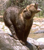
Photo: California
Academy of Sciences
On the CD: The Bear of San Mateo
Bear growl and Flintlock Rifle Gunfire
They killed a bear near Crystal Springs on their way
back to San Mateo Creek, and later presented the hide
to the Viceroy. Father Font describes on March
29, 1776, "...Here the commander decided to go to
explore a nearby valley called San Andrés, which
is in the range of the spruce trees, also called redwood...to
see if it had good timber for the settlement at the
port...We traveled through the valley some four leagues
to the southeast and southeast by south, and crossed
the arroyo of San Matheo where it enters the pass through
the hills. About a league before this there came
out on our road a very large bear, which the men succeeded
in killing. There are many of these beasts in that country,
and they often attack and do damage to the Indians when
they go to hunt, of which I saw many horrible examples.
When he saw us so near the bear was going along very
carelessly on the slope of a hill where flight was not
very easy. When I saw him so close and that he was looking
at us in suspense I feared some disaster. But Corporal
Robles fired a shot at him with aim so true that he
hit him in the neck. The bear now hurled himself down
the slope, crossed the arroyo, and hid in the brush,
but he was so badly wounded that after going a short
distance he fell dead. Thereupon the soldiers skinned
him and took what flesh they wished. In this affair
we spent more than an hour here. The commander took
the hide to give as a present to the Viceroy. The bear
was so old that his eye teeth were badly decayed and
he lacked one tooth, but he was very fat, although his
flesh smelled much like a skunk or like musk. I measured
this animal and he was nine spans long and four
high. He was horrible, fierce, large and fat, and very
tough. Several bullets which they fired at him when
he fled they found between his hide and his flesh, and
the ball which entered his throat they found in his
neck between the hide and the muscle with a little piece
of bone stuck to it."
1 league is about 2.56 miles; 1 span is about 9 inches.
Play MP3 file of Story
of the Bear of San Mateo Alan Brown tells the story of the bear.
(playing time 5 minutes 23 seconds)
Additional Resources
El Palo Alto Park, City of Palo Alto - 250
Hamilton Ave, Palo Alto, CA 94301;
tel.: 650-329-2100,
web: cityofpaloalto.org
California Historical Landmarks, CA Dept. of Parks & Recreation,
Office of Historic Preservation - P.O. Box 942896 Sacramento,
CA 94296;
tel.: 916-653-6624,
web: ohp.parks.ca.gov
Heritage Park, Burlingame Parks & Recreation Dept. - 850 Burlingame
Ave, Burlingame, CA 94010;
tel.: 650-558-7300,
web: burlingame.org/
Index.aspx?page=424
Crystal Springs and Sawyer Camp Trail County of San Mateo
- 455 County Center, 4th Floor, Redwood City, CA 94063-1646;
tel.: 650-363-4021,
web: parks.smcgov.org
San Francisco Bay Trail;
tel.: 510-464-7919
web: baytrail.org/
Coyote Point Museum - 1961 Coyote Point Dr., San Mateo, CA
94401;
tel.: 650-342-7755,
web: curiodyssey.org/
To purchase detailed maps of the various regions through which
the Anza trail traverses, visit the USGS store in Menlo Park,
California;
web: usgs.gov
or http://store.usgs.gov