The view north from the Selby Open
Space area
Photo: NPS
Driving Directions for Auto Route
Continuing on the route from Alameda
County, go north on I-80 to Hercules and exit at San Pablo Ave./CA
4, going west under the freeway to San Pablo Avenue. At San Pablo
Ave, turn right (north) to the town of Rodeo and visit the area
of campsite #99. Continuing north on San Pablo Ave., cross under
I-80 into the town of Crocket. There will be several street name
changes: San Pablo Ave. to Pomona St. east that becomes Carquinez
Scenic Drive.
Continuing on Carquinez Scenic Dr., turn right (south) on
McEwen Rd. near Port Costa to CA 4. There, turn left (east) on CA
4 to the Alhambra Way exit. Follow the signs to John Muir National
Historic Site. Continue east on CA 4. There are several places to
access the Delta-de Anza Regional Trail of the East Bay Regional
Park District. Follow CA 4 east to the town of Oakley and then follow
CA 4 south through Brentwood (Brentwood Blvd. to Byron Highway).
To continue along this route, see the section of the Trail Guide
called Getting Back/Mt. Diablo.
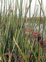
Tule (Scripus acutus) grows
throughout California along
marshes, lakes and stream-
sides. American Indians had
many uses for it.
Photo: Greg Smestad
About
Your Visit to Contra Costa County
Anza's exploratory group camped near Rodeo at the mouth of
the San Pablo Bay. The next day at noon, they stopped on a
hill just west of the Carquinez Bridge and noted Mare
Island and the Puerto Dulce (Suisun Bay). They continued to
the Martínez area and camped near Concord. They reached
the site of Antioch, and encountering impassable Tule marshes,
headed south back towards Monterey.
Sites of Interest
A. Rodeo and Expedition Camp #99
Anza's men chased Tule
Elk (Cervus elaphus nannodes) near Berkeley, and
then continued north. On April
1st, the group camped at a small stream. Today, the campsite
is at the conjunction of Parker and San Pablo Avenues and
Rodeo Creek, a heavily industrialized area. A commemorative
marker from the 1976 reenactment is on Parker Road between
4th and 6th Street in front of the post office in the town
of Rodeo. The coast reminded Font of Sonora's Tierra Caliente
(Hot Country).
B. Selby Open Space Area and Anza's
Midday Stop
West of the Carquinez Bridge, their hillside vantage
point can be reached via San Pablo Ave. through the East
Bay Regional Park District's (EBRPD) Selby Open Space
area across from Vista del Rio Road. A short, but steep, hike
from the parking area takes you to the viewpoint. On April
2, 1776, Father Font notes, " This Puerto Dulce
[sweet harbor], indeed, is a gulf of fresh water, enclosed
in a canyon by hills...In the bay and in front of the mouth
there is an island [Mare Island] " The location of the hill
is close to 38º 03' 14" N, 122º 14' 37" W.
C. Adobes of Expedition Descendants
near Camp #100
Located within the grounds of John
Muir National Historic Site, the Vicente Martínez
adobe provides interpretation of the passage of the Anza expedition
and the subsequent Spanish and Mexican periods. The wife of
Vicente Martínez was Guadalupe Moraga, a great-granddaughter
of the San Francisco founder. While in Concord, one can visit
the Salvio Pacheco Adobe (1870 Adobe St.) or the Don Fernando
Pacheco Adobe (3119 Grant St. within Hillcrest Park). Juan
Salvio Pacheco, a grandson of Anza recruit Juan Salvio Pacheco
and his wife, María del Carmen del Valle, received
a 5,000-acre Mexican land grant for service to his government.
Fernando was their son.
D. Recreation Trails along
Anza's Path
The East
Bay Regional Park District's (EBRPD) multi-use 20-mile
Delta
de Anza Regional Trail commemorates the route of Anza's
1776 expedition and is marked as a component of the Juan
Bautista de Anza National Historic Trail. An interpretive
stop located on the eastern side of Willow Pass describes
the Puerto Dulce. EBRPD manages hundreds of miles of
trails including the Skyline
National Recreation Trail. This trail, and the Bay
Area Ridge Trail parallel Anza's route, although at a
higher elevation so that they offer panoramic views of San
Francisco Bay. At both the Carquinez
Strait and Antioch
/ Oakley Regional Shoreline parks give a closer view.
At the latter, Camp #101 is commemorated with a plaque placed
on the edge of the shore on the east side of the fishing pier.
Near this camp on April
3rd, there was a friendly exchange with members of a Bay
Miwok village.
Learning On The
Trail in Contra Costa County
Photo: NPS
Trail Questions
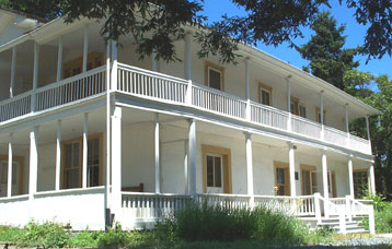
Don Vicente Martínez, son of the Presidio of San Francisco's
commandante, built this adobe house around 1849.
Question: Who founded the Presidio, and when?
On the CD: The Bay Miwok
Anza and the small band of soldiers explored the East Bay,
camping near Rodeo at the mouth of the San Pablo Bay. On April
2, 1776 natives were encountered in Contra Costa County near
Rodeo, and Font describes a rather long stick split in the
middle. The stick was an Ohlone clapper stick, and the natives
were from a large east bay Chocheno village. Anza and his
men continued to the village, and were presented with gifts.
As the soldiers left, the Chocheno followed after them with
their singing and dancing, which Font interrupted by chanting
the Alabado (see below to listen to Alabado
MP3 file)and they responded in a higher key, as
if they wished to respond to the chant. Traveling to the future
site of Antioch, Anza's group began their journey south back
towards Monterey. On April 3, Father Font writes, " we came
to a good-sized village, whose Indians, who in color and all
other respects are like the rest, welcomed us as friends although
timidly We stopped for a while at this village, whose huts
were not of grass and dilapidated like those we had seen during
this journey, but "rather large, round, and well made, like
those of the [Chumash] Channel The commander made an effort
to please the Indians, giving them glass beads to dispel their
fear." Font goes on to tell that some of the native women
and children jumped into the water into well made boats made
of tule (reeds). The native men remained outside talking
rapidly. One man put out a long pole with feathers on the
end, and a long strip of rabbit skin hung from it like a banner.
This was taken as a sign of peace. We can not know what was
said, but according to linguist Dr. Catherine A. Callaghan,
the tribe was likely the Julpun group of the Bay Miwok tribe,
and some of their words are:
Miwok
English
Julpun
neighbor place
Play MP3 file of The Bay
Miwok
narrated by
Catherine A. Callaghan
(playing time
1 min. 17 sec.)
Play MP3 file of The
Alabado
performed by
John Warren (Chant)
Calicanto (Choral)
Lance Beeson (Guitar)
(playing time
3 min. 43 sec.)
olé
coyote
kik·u
water
kik·u maaye
water lady
weno
medicine
weno mayo
medicine person
hoowok
beads
'oyya
relative
hoy·u maaye
first lady
helwash
top person
yayeume
talk
yayeumekay
talker
Additional Resources
Rodeo is an unincorporated town in Contra
Costa County;
web: rodeoca.org
John Muir National Historic Site and Martínez Adobe
- 4202 Alhambra Ave., Martinez, CA 94553-3883;
tel.: 510-228-8860,
web: nps.gov/jomu
Contra Costa Historical Society - 610 Main St., Martinez,
CA 94553;
tel.: 925-229-1042
web: cocohistory.com
Salvio Pacheco Adobe - 1870 Adobe St. (at Salvio St.), Concord,
CA 94519;
Fernando Pacheco Adobe - 3119 Grant St., Concord, CA 94519;
tel.: 925-671-3000,
web: cityofconcord.org/
about/historicalbldgs.htm
Moraga Historical Society Library - 1500 St. Mary's Rd., Moraga,
CA 94556-2099;
tel.: 925-377-8734,
web: moragahistory.org
Lindsay Wildlife Museum - 1931 First Ave., Walnut Creek, CA
94597;
tel.: 925-935-1978,
web: wildlife-museum.org
Delta de Anza Regional Trail and East Bay Regional Park District
- P.O. Box 5381, Oakland, CA 94605-0381;
tel.: 925-625-5479,
web: ebparks.org